Snowpack Science in Action - What Snow Observations Reveal About Climate and Water
Every spring, rivers in the American West fill with snowmelt, turning what was once frozen white into the lifeblood of cities, farms, and ecosystems. But knowing how much water is locked in the snowpack isn't simple. It can't be eyeballed. It has to be measured, modeled, and sometimes guessed. Snow Observations brings together methods, research, and practical data to make sense of this seasonal bank account—and how it's shifting in a warming climate.
Observation Methods in Snowpack Science
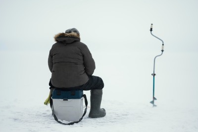
Snow is measured in ways that are both basic and highly technical. Manual snowpits remain a mainstay in mountain science. Technicians dig down, layer by layer, taking depth and density measurements to calculate snow water equivalent (SWE)—the actual volume of water that would result from melted snow.
But hand-digging only goes so far. The SNOTEL system automates this across western North America. These stations use pressure sensors to estimate SWE alongside daily temperature and precipitation records. What's less known is how spatially limited they are—most stations are installed in sheltered forest clearings near access roads.
To fill the gaps, satellites and aircraft come in. Instruments like MODIS and Landsat track snow cover and albedo. Airborne campaigns use LiDAR and radar to map snow depth with resolution satellites can't match. NASA's Airborne Snow Observatory (ASO), for example, has flown over the Sierra Nevada, creating near-complete maps of SWE at 50-meter resolution. Still, these datasets have short histories and require careful calibration.
That's where modeling steps in. Researchers now use attention-based neural networks and long short-term memory (LSTM) models to reconstruct SWE time series from a mix of point-based data and remote sensing. These are helping fill in decades-long records across places like the Upper Colorado River Basin, where complete SWE histories were previously out of reach.
Snow Water Equivalent and How It's Measured
SWE is a simple concept with huge implications. It answers the question: how much water is stored in the snowpack right now? Not all snow is equal. Light powder might look deep but yield little water, while dense snow may pack a punch in just a few inches.
Peak SWE tells us the maximum potential runoff available for the season. However, recent research has gone a step further, introducing the Snow Water Storage (SwS) metric. SwS doesn't just measure the peak—it integrates how much water is held in snow throughout the season, factoring in both magnitude and duration.
This matters because water managers aren't only interested in how much snow there is at one moment but how long it will release water into rivers. SwS, expressed in meter days, gives a more accurate picture of seasonal water availability than a single-day SWE snapshot.
Trends in Snowpack and Climate Implications
Snowpack is declining, but not evenly. In the western U.S., April 1 snowpack levels—once used as a reliable benchmark—have dropped sharply in many basins since the 1980s. This means earlier snowmelt, shorter snow seasons, and changes in runoff timing that affect agriculture and ecosystems.
Studies of satellite data and long-term station records confirm this. From 1982 to 2016, SWS fell by over 20 percent in most U.S. mountain regions. That's equivalent to removing vast volumes of water from a natural storage system. The loss hits especially hard in watersheds like the Cascades, Rockies, and Sierra Nevada—where downstream users depend heavily on spring and summer runoff.
That said, not all regions show the same patterns. Some basins in Asia, including parts of the Tibetan Plateau, have experienced snowpack increases, likely tied to shifts in precipitation. Local changes in elevation, forest cover, and storm frequency all influence these outcomes.
Impacts on Water Management and Reservoir Operations
For water managers, snowpack isn't academic. It sets the tone for the whole year. Reservoir operators use SWE forecasts to plan releases and storage strategies. Hydropower utilities need to know when peak inflow will occur. Cities and irrigation districts watch SWE maps closely to predict shortages or floods.
The SNOTEL network feeds directly into these forecasts. Alongside soil moisture data and meteorological inputs, SWE helps guide runoff models used by federal and state agencies. Forecasts aren't perfect, but they've gotten better—especially as they incorporate satellite and airborne datasets.
Some water agencies now rely on ensemble modeling systems that include both physics-based hydrology and machine learning. These models can simulate different snowmelt and runoff scenarios, giving reservoir operators a set of possibilities rather than a single number.
Impacts on Agriculture Ecosystems and Climate Planning
In farming regions that rely on irrigation, the timing of snowmelt matters as much as the amount. Earlier melt means earlier water availability—but it can also mean a longer dry season and more reliance on reservoirs to stretch the water supply into late summer.
Plants and animals are also affected. Alpine wildflowers may bloom earlier and miss pollination. Snow-dependent species like the wolverine or Sierra Nevada red fox may find their habitat shrinking. Earlier snowmelt can leave soils drier during fire season, increasing wildfire risks.
On the planning side, climate models now routinely incorporate snowpack trends into regional water stress forecasts. These models help cities, power grids, and farms prepare for drier springs or rain-dominated winters that used to bring snow. In some places, planners are reconsidering reservoir design and operation entirely, assuming snowpack may no longer act as a reliable buffer.
Case Studies and Use Cases
In the Sierra Nevada, scientists used snow-course data going back to 1940, combined with reanalysis models and satellite observations, to build an 80-year SWE reconstruction. This revealed not just a declining trend but an increase in year-to-year variability—making water supply harder to predict.
In Colorado, the Grand Mesa field campaign gathered detailed snowpit profiles paired with LiDAR, radar, and microwave flights. This fieldwork helped ground-truth remote sensing algorithms and improve snow-depth estimates in forested terrain, where satellite data often fails.
Another study used machine learning across 323 SNOTEL sites. Attention-based models learned to predict daily SWE by identifying spatial and temporal patterns in temperature and precipitation. These tools helped fill gaps in SWE maps, especially in under-sampled areas. Meanwhile, LSTM models reconstructed historical SWE at a daily scale across the continental U.S.—a step forward in understanding long-term snowpack behavior.
Technology and Data Integration Hub

Public access to snow data has improved. The NRCS operates user-friendly tools for tracking daily SWE, snow depth, and percent-of-median statistics across basins. These tools are used widely by hydrologists, water boards, and researchers.
NASA's Earthdata platform offers gridded SWE datasets from satellite sources like AMSR and MODIS, matched with demographic overlays to connect snowpack trends to water demand. While technical, these datasets are increasingly incorporated into academic and municipal water assessments.
Educational platforms like HydroLearn are helping students and professionals alike understand how to apply these datasets. Some modules walk through seasonal SWE modeling, comparing basins and linking snowpack to downstream flow and storage capacity.
Challenges and Future Directions
There's still a gap between what we know and what we need to know. Manual snow courses are disappearing. Remote sensing struggles under forest canopy or in cloudy conditions. And machine learning models, while promising, depend on quality data that can be hard to obtain in remote mountain regions.
Combining all these tools—manual, remote, and modeled—is the way forward. The field is moving toward integrated snow observatories that pair satellite snapshots with drone flights, real-time stations, and physics-based simulations. The goal is to reduce uncertainty and improve year-round SWE estimates across large, complex basins.
As satellite technology improves, we may see higher-frequency snow depth updates, even daily, in some regions. This would allow near-real-time snowmelt forecasting, which is crucial for flood response and reservoir operations during warm, rainy winters.
Next Steps for Snow Observations
Snow Observations will keep tracking methods and research in snow science. We'll feature practical tools—like basin SWE maps, percentile trend graphs, and climate-linked water forecasts. We'll also continue reviewing how machine learning and remote sensing compare in different settings.
New case studies from places like the Indus Basin, where snow-fed rivers support hundreds of millions, are on the horizon. So is a deeper look at how agricultural policy adapts to early melt and dwindling spring reserves.
The future of snowpack research is already underway. But to manage water well, it has to be seen, measured and understood. That's where observation begins.